Raymond’s Geography: Rivers, Landmarks, and Nature
What makes a small town like Raymond, Washington, feel like a hidden gem? Tucked in Pacific County, this coastal spot blends winding rivers, historic sites, and wild forests in just 4.7 square miles. The geography of Raymond shapes its charm, drawing visitors to paddle its waters, explore old buildings, and hike misty trails. Let’s walk through what makes this place special and how you can experience it.
Why Raymond’s Geography Stands Out
Raymond sits where the Willapa River and its South Fork meet, close to Willapa Bay. The town covers 4.09 square miles of land, with water weaving through the rest. At sea level, tides shape daily life. Steep Willapa Hills surround the area, cradling dense forests. Rain falls often—about 83 inches a year—keeping everything green. Summers stay cool, rarely topping 75°F, perfect for outdoor trips.
The land’s history ties to its rivers and trees. Native tribes, like the Lower Chehalis, fished here long before settlers arrived in the early 1900s. They built Raymond on stilts over muddy sloughs, a clever fix for the soggy ground. Today, solid streets and trails let you explore this unique setting.
To get a feel for Raymond, imagine strolling along a riverbank with old-growth trees overhead. You’re never far from water or history here.
Rivers That Shape Raymond
Rivers define the geography of Raymond. They offer scenic views, fishing spots, and paths for kayaking. Grab a paddle or take a walk to see them up close.
Willapa River
The Willapa River flows from the hills to Willapa Bay, cutting through downtown Raymond. In the past, loggers used it to float timber to mills. Now, it’s a calm spot for kayaking. Launch from Riverfront Park to glide past grassy banks. Look for salmon in fall or bald eagles perched nearby. The river’s steady flow makes it beginner-friendly. Check local tide charts before heading out, as water levels shift.
South Fork Willapa River
This smaller branch joins the main river near town. It’s quieter, with tree-lined banks perfect for a short paddle. Trails near the fork let you hike above the water for a different view. In autumn, spawning fish draw birds, so bring binoculars. The South Fork’s calm waters suit families or solo adventurers looking for peace.
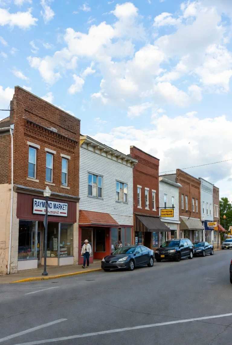
Must-See Landmarks in Raymond
Raymond’s landmarks reflect its past and its place in the landscape. Most are walkable, tying the town’s history to its rivers and hills.
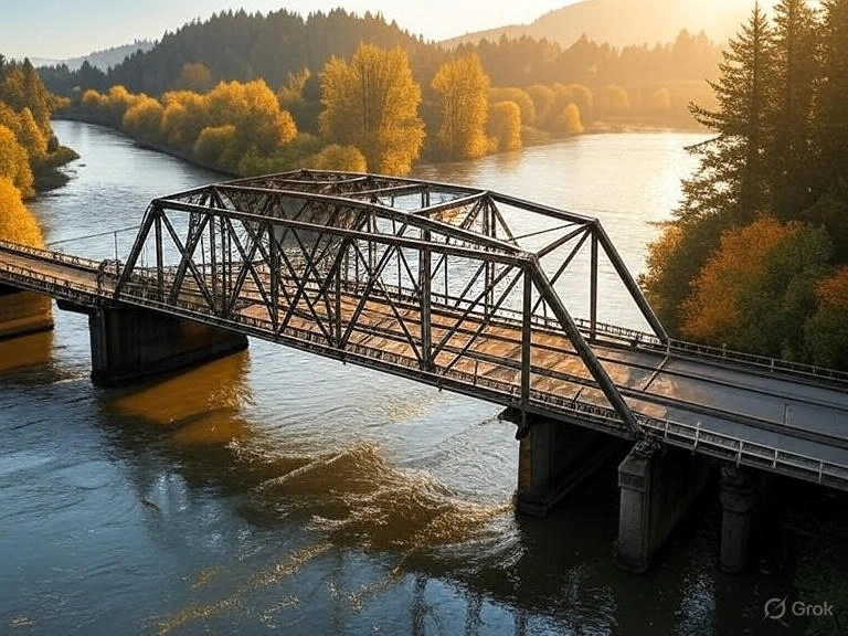
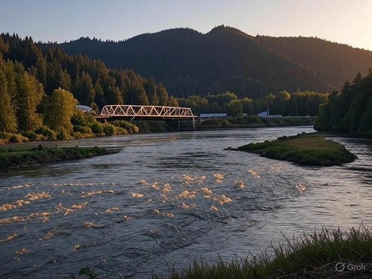
Willapa River Swing Bridge
An old train bridge spans the Willapa River near downtown. Built to swing open for boats, it’s now a relic of the logging era. Locals hope to link it to nearby trails for hikers. Walk across to see the river below and feel the town’s industrial roots. It’s a quick stop with big views.
Wildlife Heritage Sculpture Corridor
Along Highway 101, over 200 steel sculptures of animals like elk and birds line the road. Started in 1993, they celebrate the area’s wildlife. Bike or drive this stretch to spot them all. Pair it with a walk on the nearby Willapa Hills Trail for a full day out. The sculptures add a unique touch to Raymond’s streets.
Historic Sites and Museums
The Northwest Carriage Museum displays wagons from the logging days, some featured in movies. The Willapa Seaport Museum dives into the bay’s maritime past with old tools and maps. Raymond Theatre, opened in 1928, still hosts plays and concerts. Visit these spots to see how the land and rivers shaped the town’s story. Check museum hours online before going.
Natural Features to Explore
Raymond’s natural features draw hikers, birdwatchers, and nature lovers. Forests, wetlands, and hills create a playground for outdoor activities.
Willapa Hills and Forests
Thick forests cover the Willapa Hills around Raymond. Some trees are centuries old, home to deer and small mammals. Trails in Bruceport County Park, just outside town, wind through 120 acres of towering pines. Hike the paths for shade and quiet. Early mornings offer the best chance to spot wildlife. Wear sturdy shoes—trails get muddy after rain.
Tidelands and Wetlands
Near the river’s mouth, tidelands mix fresh and saltwater. These wetlands teem with birds like herons and ducks. Jensen Island, built from dredged dirt in the 1930s, is a great spot to kayak. Try the Willapa Water Trail for a guided route through the estuary. Bring a waterproof map and check tide schedules to avoid getting stuck.
Parks and Trails
Riverfront Park offers benches and paths along the Willapa River. It’s a good spot for a picnic or short walk. The Willapa River Trail follows the water, connecting to downtown. For a longer trek, the Willapa Hills Trail runs miles along an old rail line, passing rivers and valleys. Download trail maps from AllTrails for clear routes and tips.
Tips for Visiting Raymond
To make the most of Raymond’s geography, plan ahead. Here’s how:
- Kayak the Rivers: Rent kayaks locally or bring your own. Start at Riverfront Park for easy access. Paddle early to avoid crowds.
- Walk the Landmarks: Park downtown and explore the swing bridge, sculptures, and museums on foot. Most are within a mile.
- Hike the Hills: Head to Bruceport County Park for forest trails. Pack rain gear and check trail conditions online.
- Check Tides: Tidelands and rivers shift with tides. Use NOAA’s tide charts for safe kayaking or hiking.
- Visit in Fall: Cooler weather and spawning fish make autumn ideal for wildlife spotting.
Why Raymond’s Geography Matters
The geography of Raymond weaves rivers, landmarks, and natural features into a small but vibrant package. Its waterways offer adventure, its historic sites tell stories, and its forests invite exploration. Whether you’re paddling the Willapa River or hiking the hills, this town delivers a slice of Washington’s coastal beauty.
Ready to explore? Pack your boots, grab a map, and head to Raymond. The rivers and trails are waiting.